Indigenous Peoples and Lands
Indigenous Peoples
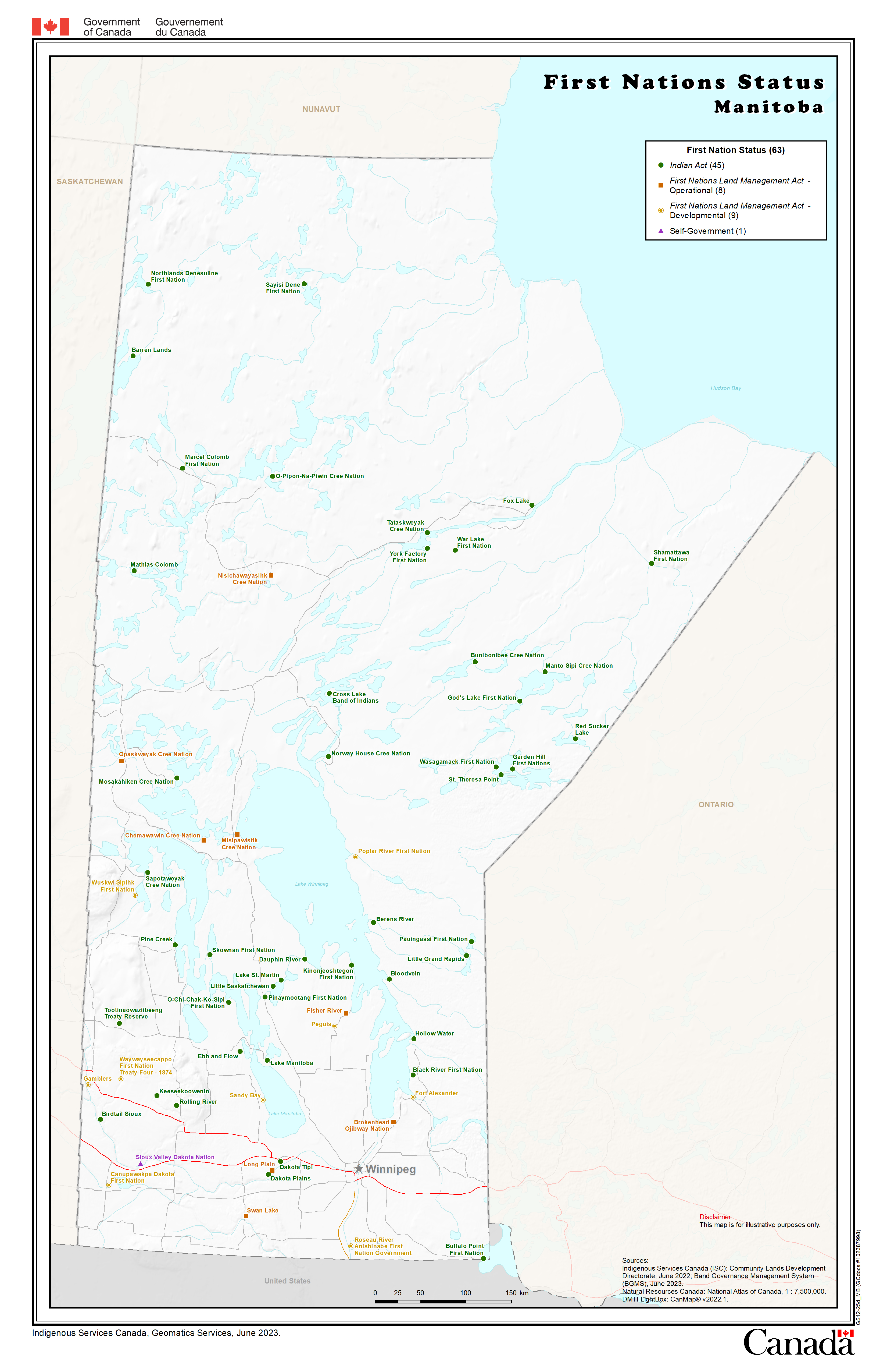
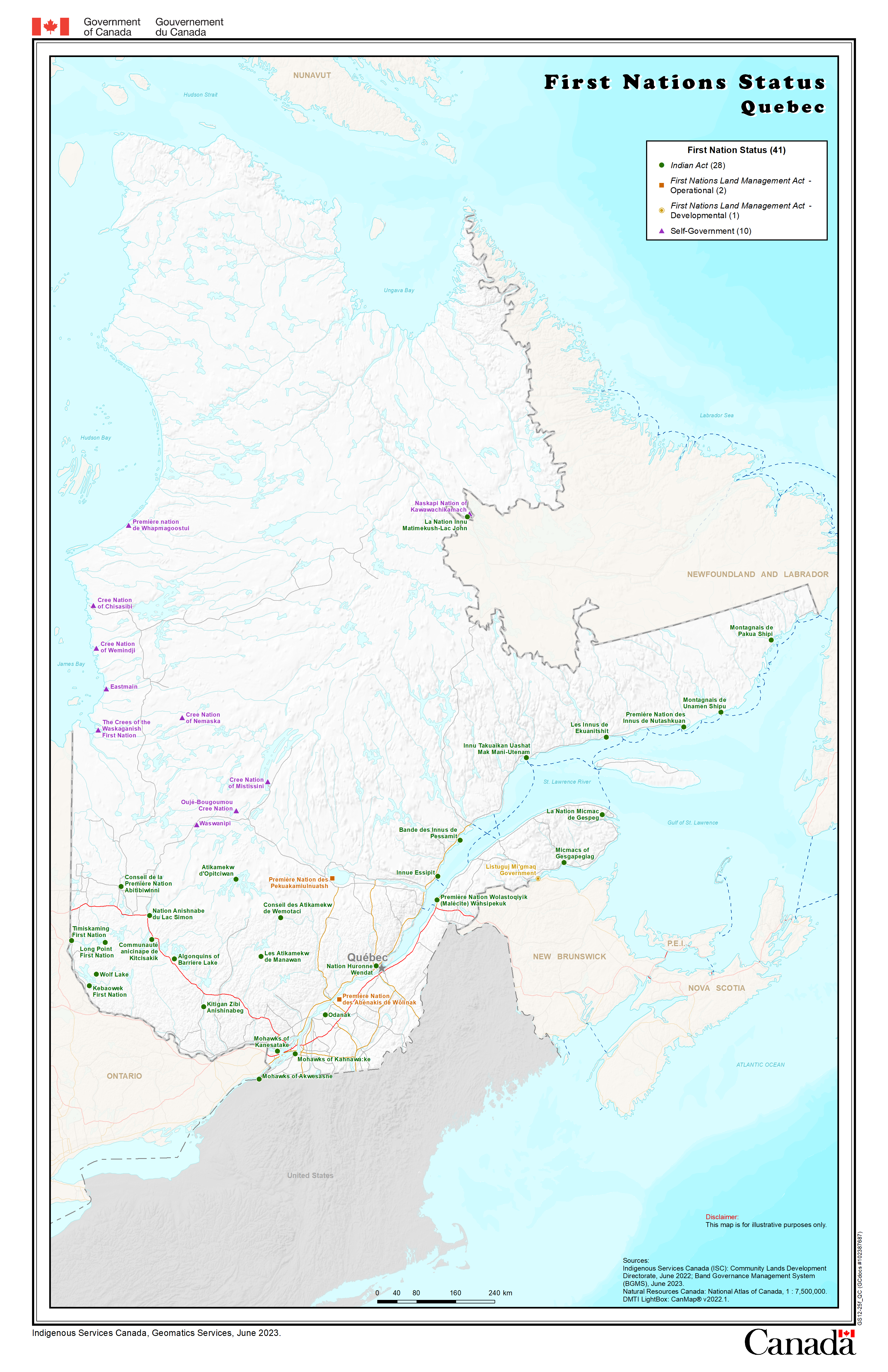
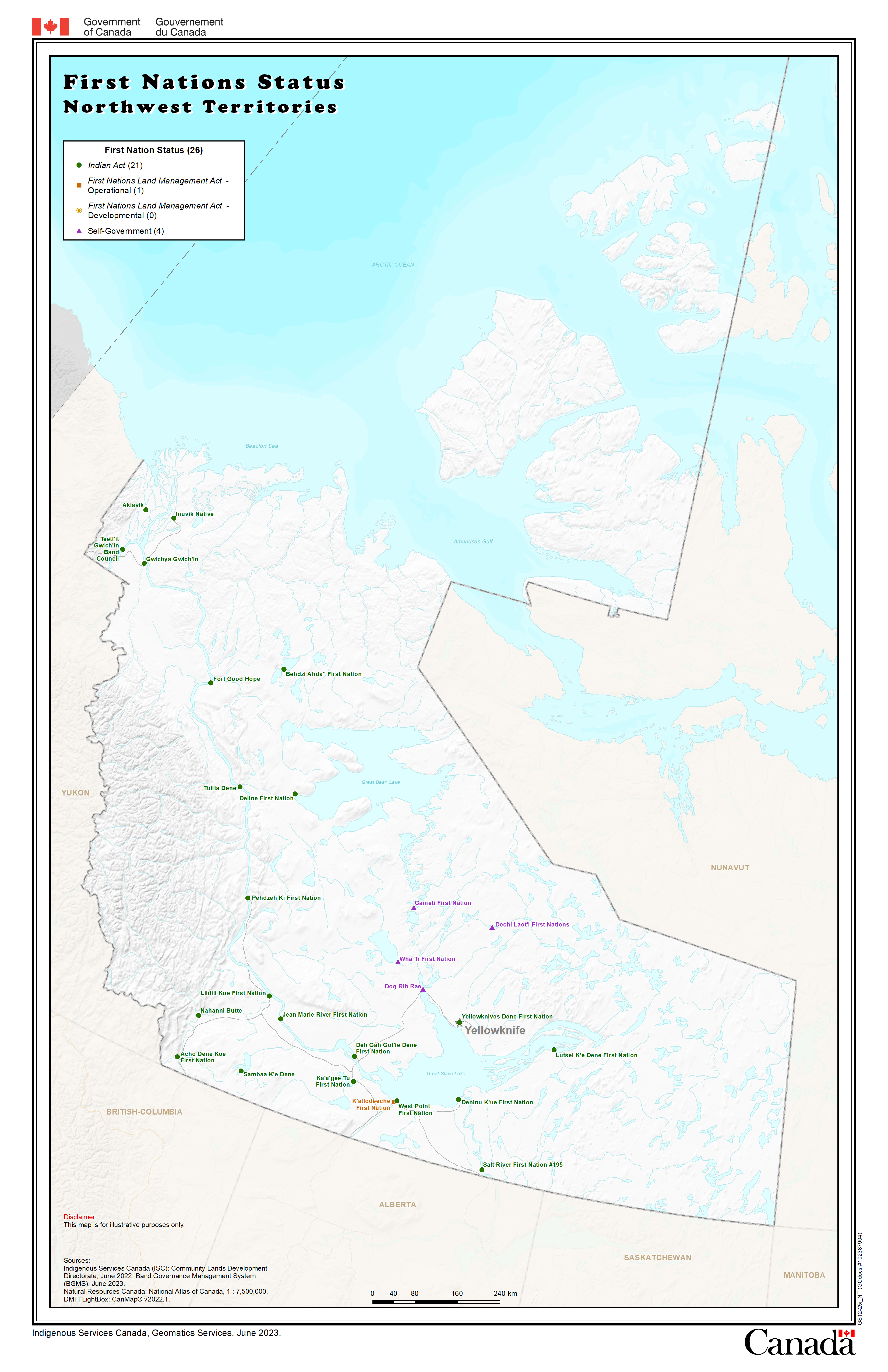
First Nations in Canada

These maps show the status of First Nations in Canada symbolized as the Indian Act, the Land Management Act or Self-Government.
Static maps, data
Static maps
Maps of Canada
- Largest wall size (42 inches by 50 inches or 106.68 centimeters by 127 centimeters)
- PDF (21,317 KB)
- Tabloid size (11 inches by 17 inches or 27.94 centimeters by 43.18 centimeters)
Regional maps
- British Columbia (17 inches by 11 inches or 43.18 centimeters by 27.94 centimeters)
- Alberta (17 inches by 11 inches or 43.18 centimeters by 27.94 centimeters)
- Saskatchewan (17 inches by 11 inches or 43.18 centimeters by 27.94 centimeters)
- Manitoba (17 inches by 11 inches or 43.18 centimeters by 27.94 centimeters)
- Ontario (11 inches by 17 inches or 27.94 centimeters by 43.18 centimeters)
- Quebec (17 inches by 11 inches or 43.18 centimeters by 27.94 centimeters)
- Atlantic (17 inches by 11 inches or 43.18 centimeters by 27.94 centimeters)
- Yukon (17 inches by 11 inches or 43.18 centimeters by 27.94 centimeters)
- Northwest Territories (17 inches by 11 inches or 43.18 centimeters by 27.94 centimeters)
For additional map formats, please contact infopubs@sac-isc.gc.ca.
Data
GeoViewer

The GeoViewer is a full-fledged "Web GIS". It provides viewing, searching, measuring, adding, sharing and printing of some departmental geographic data.
Interactive map, data
Interactive map
Data
British Columbia - First Nations communities

This map shows the geographic location of the main community of each British Columbia First Nation.
Static map, data
Static map
- British Columbia - First Nations communities (4,646 KB PDF) (11 inches by 17 inches or 21.94 centimeters by 43.18 centimeters)
Data
Quebec - The Nations

This map presents various information on the population of Indigenous communities in Quebec.
Static map, data
Static map
Data
First Nation Profiles

This interactive map shows a collection of information that describes individual First Nation communities across Canada.
Interactive map, data
Interactive map
The profiles include general information on a First Nation along with more detailed information about its reserve(s), governance, federal funding, geography, registered population statistics and various Census statistics.
Data
Inuit Nunangat

The Inuit Nunangat represents all 51 inhabited and serviced Inuit communities living on four Inuit regions across the northern Canada. Explore and learn about their location, traditional name, population and other information.
Static Maps
Inuit Nunangat
- PDF (1,315 KB) (8.5 inches by 11 inches or 21.59 centimeters by 43.18 centimeters)
- PNG (905 KB) (8.5 inches by 11 inches or 21.59 centimeters by 43.18 centimeters)
Inuit Nunangat – Relocation route
This map illustrates the Inuit relocation movement from Nunavik to Nunavut. Starting in Inukjuak, Nunavik, Quebec, the relocation route finally reaches Pond Inlet before splitting off to the final destinations of Resolute Bay and Grise Fiord.
- PDF (1,524 KB) (8.5 inches by 11 inches or 21.59 centimeters by 43.18 centimeters)
- PNG (602 KB) (8.5 inches by 11 inches or 21.59 centimeters by 43.18 centimeters)
Data
Métis population

These maps show the density of Métis identity population by Dissemination Areas from Statistics Canada Census of Population for 2006.
Static maps
Statistic maps
- 2006 Census
- British Columbia (9,890 KB PDF) (60 inches by 36 inches or 152.4 centimeters by 91.44 centimeters)
- Alberta (5,775 KB PDF) (60 inches by 36 inches or 152.4 centimeters by 91.44 centimeters)
- Saskatchewan (4,577 KB PDF) (60 inches by 36 inches or 152.4 centimeters by 91.44 centimeters)
- Manitoba (6,057 KB PDF) (60 inches by 36 inches or 152.4 centimeters by 91.44 centimeters)
- Ontario (13,460 KB PDF) (60 inches by 36 inches or 152.4 centimeters by 91.44 centimeters)
- Quebec (17,068 KB PDF) (60 inches by 36 inches or 152.4 centimeters by 91.44 centimeters)
- Atlantic (10,413 KB PDF) (60 inches by 36 inches or 152.4 centimeters by 91.44 centimeters)
- North (10,258 KB PDF) (36 inches by 60 inches or 91.44 centimeters by 152.4 centimeters)
Indigenous Lands
Land registries

Indigenous Services Canada has three web-based land registries accessible to First Nations, departmental employees and the general public.
Interactive tool
The ILRS is a database of instruments registered in the Indian Lands Registry relating to Reserve Lands and Crown Lands. The FNLRS is a database of instruments registered in the Indian Lands Registry relating to Reserve Lands under the First Nation Land Management Act. The SGFNLR is a database of instruments that are registered/recorded in a First Nation's Land Registry established according to its specific Self Government Land Management Act.
Interactive tool
Electronic Registry Index Plan (eRIP)

The eRIP provides registry clients with access to electronic maps using Geographic Information System (GIS) technology.
Interactive map
The eRIP provides registry clients with access to electronic maps using Geographic Information System (GIS) technology. The GIS functionality is dependent upon the reconciliation of parcel identification numbers (PINs) between the land registry system and the NRCan Canada Land Survey System (CLSS) (it is the CLSS that will supply the data for the electronic maps).
- The eRIP map displays the status of land on reserves (Band Land, Permit, Lawful Possession, Lease Land, Designated Land) as well as detailed information on parcels ( PIN, Survey Plan Type and Number, Legal Description)
- The eRIP map is a graphical representation of the legal interests registered on Reserve Lands in the Indian Land Registry.
Interactive map
Aboriginal Lands of Canada

The Aboriginal Lands of Canada include legislative boundaries of Indian Reserves, Land Claim Settlement Lands (lands created under Comprehensive Land Claims Process that do not or will not have Indian Reserve status under the Indian Act) and Indian Lands.
The Canada Lands Survey

The Canada Lands Survey System map browser is a location-based search tool that illustrates information from Canada Lands Surveys Records in an interactive map.
Treaties, agreements and claims
Aboriginal and Treaty Rights Information System (ATRIS) Interactive Map

The Aboriginal and Treaty Rights Information System (ATRIS) is a Web-based information system intended to map out the location of Indigenous communities and conveniently displays information pertaining to potential and/or established Aboriginal or treaty rights.
Interactive map, data
Interactive map
The Government of Canada has a duty to consult, and where appropriate, accommodate Indigenous groups when it considers conduct that might adversely impact potential or established Aboriginal or treaty rights.
Data
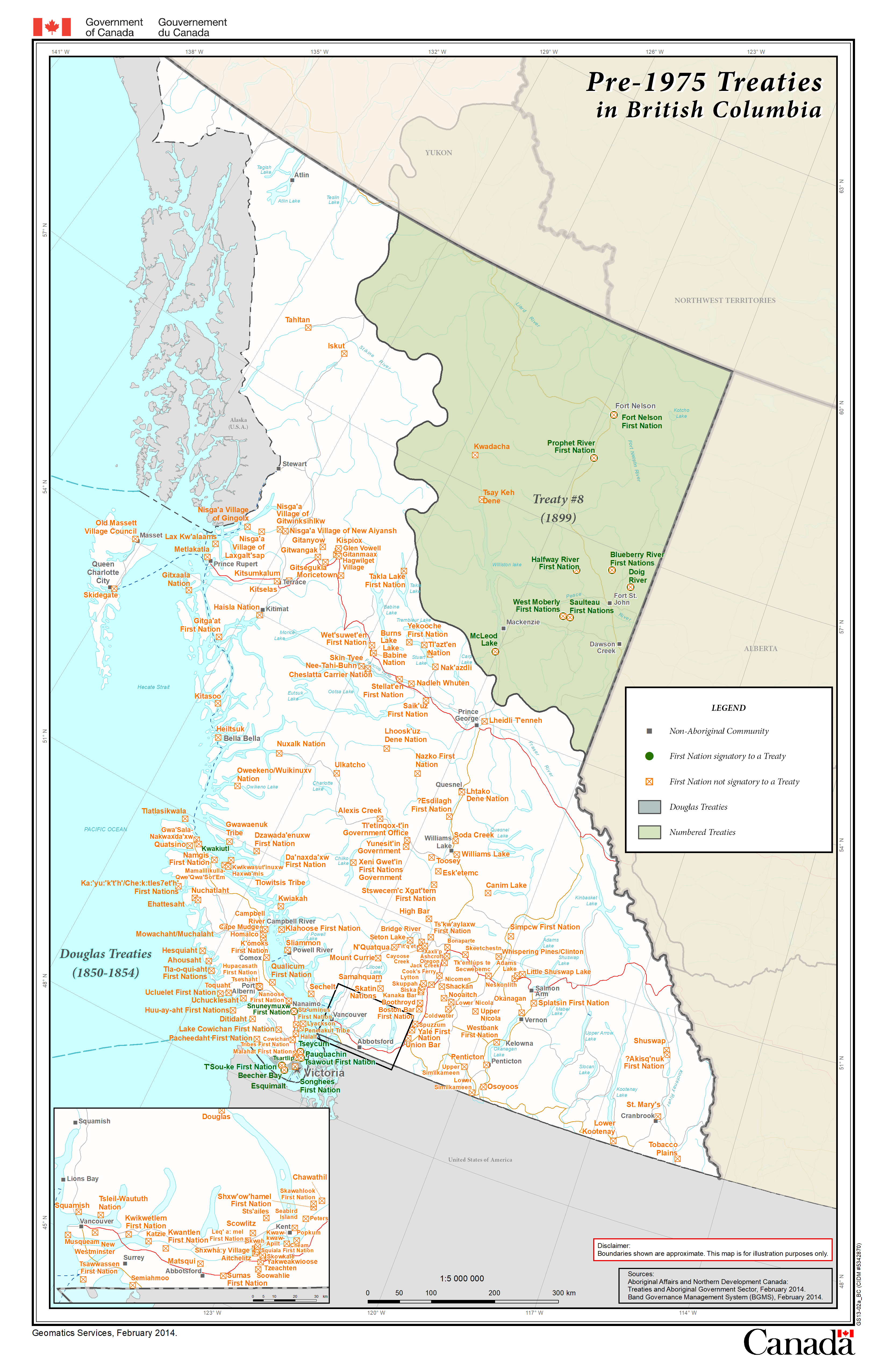
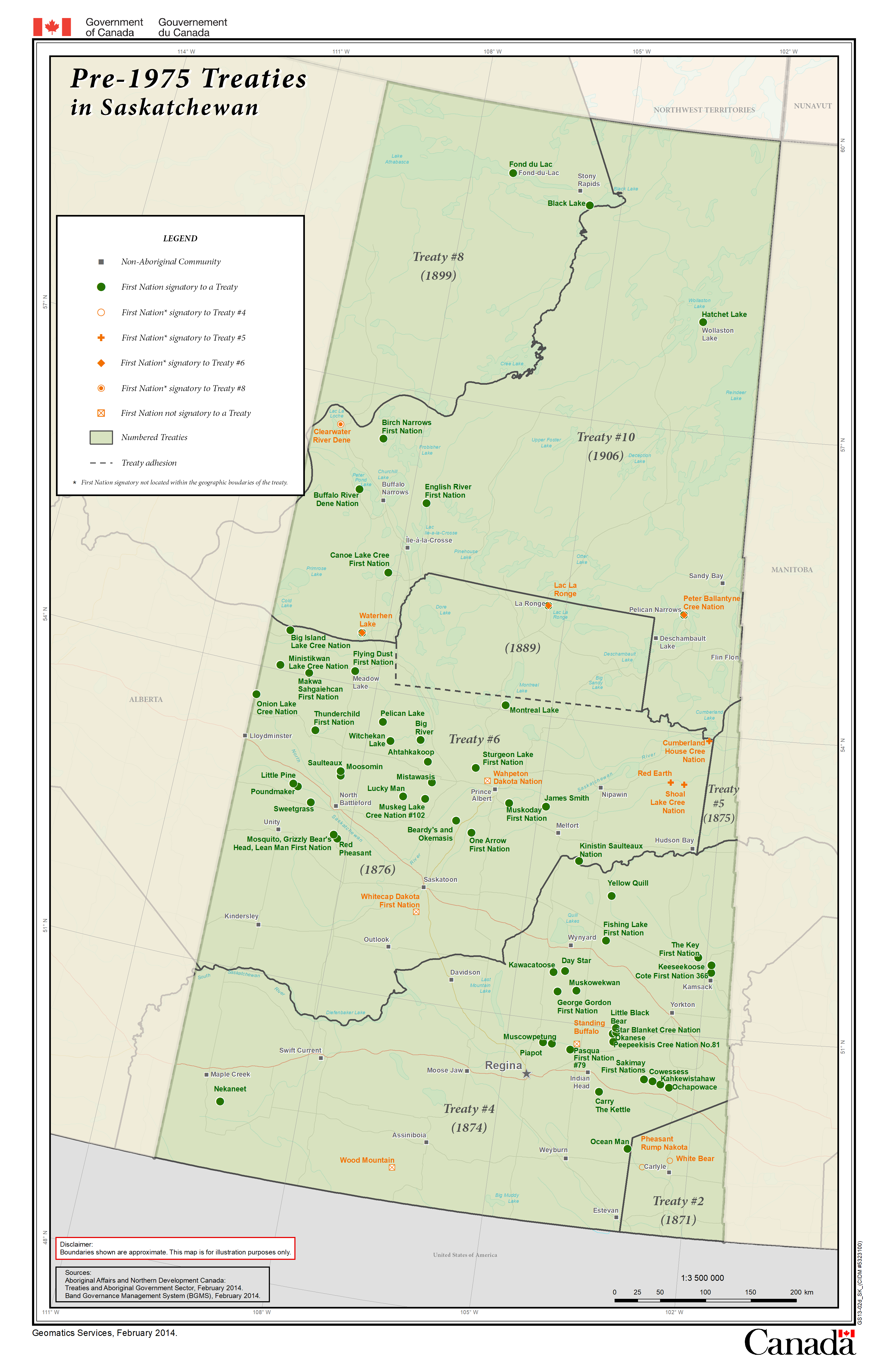
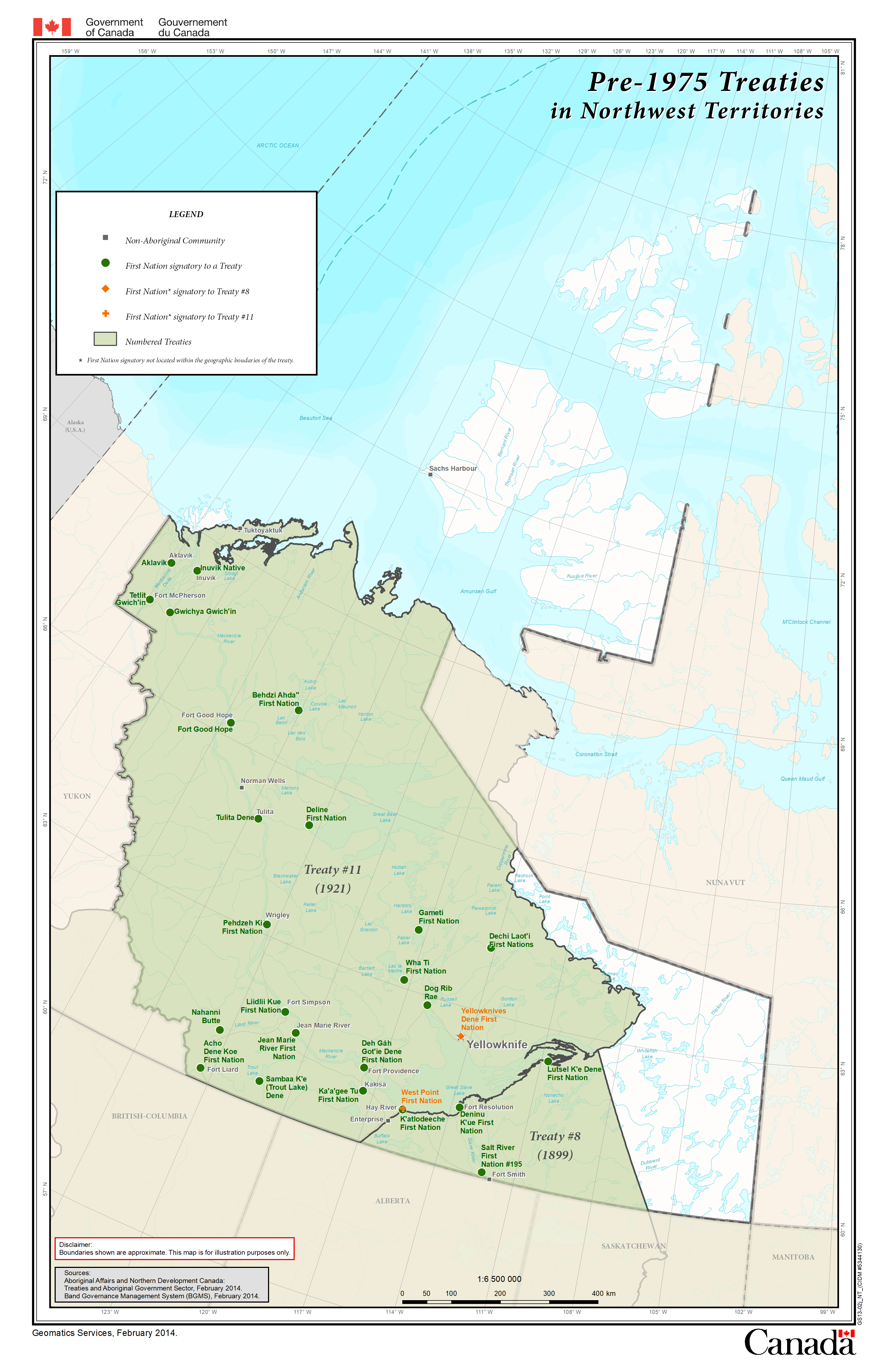
Historic Treaties

This map illustrates the boundaries of historic treaties concluded between First Nations and the British and Canadian governments from 1701 to 1930.
Static maps, data
Static maps
Maps of Canada
- Largest Wall size (6,936 KB PDF) (42 inches by 50 inches or 106.68 centimeters by 127 centimeters)
- Letter size (753 KB PDF) (8.5 inches by 11 inches or 21.59 centimeters by 27.94 centimeters)
Regional maps
- British Columbia (2,244 KB PDF) (17 inches by 11 inches or 43.18 centimeters by 27.94 centimeters)
- Alberta (1,500 KB PDF) (17 inches by 11 inches or 43.18 centimeters by 27.94 centimeters)
- Saskatchewan (1,554 KB PDF) (17 inches by 11 inches or 43.18 centimeters by 27.94 centimeters)
- Manitoba (1,520 KB PDF) (17 inches by 11 inches or 43.18 centimeters by 27.94 centimeters)
- Ontario (2,088 KB PDF) (11 inches by 17 inches or 27.94 centimeters by 43.18 centimeters)
- Quebec (1,119 KB PDF) (17 inches by 11 inches or 43.18 centimeters by 27.94 centimeters)
- Atlantic (940 KB PDF) (17 inches by 11 inches or 43.18 centimeters by 27.94 centimeters)
- Yukon (1,356 KB PDF) (17 inches by 11 inches or 43.18 centimeters by 27.94 centimeters)
- Northwest Territories (1,771 KB PDF) (17 inches by 11 inches or 43.18 centimeters by 27.94 centimeters)
Data
Modern treaties and stand-alone self-government agreements

This map illustrates the boundaries of all finalized modern treaties and stand-alone self-governments between Indigenous communities and the Canadian government.
Static map, data
These agreements have been ratified and brought into effect since the announcement of the Government of Canada's Comprehensive Land Claims Policy in 1973 and the establishment of the BC Treaty Process (1992).
More information on Modern Agreements.
Static map
- Letter size (8.5 inches by 11 inches or 21.59 centimeters by 27.94 centimeters)
Data
British Columbia - Treaty negotiations

This map shows the approximate traditional territories of the First Nations which entered the British Columbia Treaty Process, as described in their statements of intent to negotiate a treaty. It also shows the areas in which Final Agreements are completed and in effect.
Static maps, data
Static maps
- British Columbia - Treaty negotiations (Wall size) (7,666 KB PDF) (17 inches by 22 inches or 43.18 centimeters by 142.24 centimeters)
- British Columbia - Treaty negotiations (Letter size) (3,140 KB PDF) (8.5 inches by 11 inches or 21.59 centimeters by 27.94 centimeters)
Data
- First Nation Statement of Intent Boundaries BC (English only)
- First Nations Treaty Areas (English only)
Specific Claim Settlements

The Government of Canada has a policy and process in place for resolving specific claims through negotiations. Explore to learn about specific claims settled through negotiations with First Nations since 1973.